We can combine baseline data derived from existing and archived sources with today’s current digital information data sources to create a cost-effective integrated solution for project-specific answers for management and planning.
The use of Geographic Information Systems (GIS) has become an indispensable tool for environmental management and planning applications. GIS uses sophisticated geographic software to process data that has a spatial component. When data are entered into a GIS they are stored in layers that allow the user to combine the spatial elements of a map with the information capabilities of a database.
We have used GIS to generate spatial databases for a wide variety of projects. Our experience with ESRI’s ArcGIS applications, the standard for GIS mapping and spatial data analysis, and Global Positioning System (GPS) instruments, further enhances our ability to provide environmental planning, assessment, and analysis to assist our clients in addressing diverse environmental issues.
Key mapping applications and experience:
- Regional habitats
- Spatial constraints
- Marine spatial planning
- ROV and UAV (drone) surveys
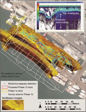
- Seagrass and project footprint interactions
- Invasive Caulerpa
- Acoustic fish surveys
- Sedimentation studies
- Thermal plume from industrial discharges
- Bathymetry and depth change analysis over time
Additional link to the San Luis Obispo GIS User Group website

CA DGS Certified Small Business #34521
141 Suburban Rd, Ste A2, San Luis Obispo, CA 93401. (805) 541 0310
© 2018, Tenera Environmental. All rights reserved.